
Page 30 - Industrial Plants
P. 30
reaches 40 m of water depth. It was, therefore, preferred This correlates with a lack of disseminated iron
to use the geoelectric resistivity method with tomographic usually characteristic of the lowermost and topmost
processing (ERT). In addition, considering the need to Beds. This lack of disseminated iron in turn correlates
maintain a high resolution capacity, as well as the with an increase in the amount of clay within the
considerable depths involved in the outermost area, it Member at this locality. It is atypical concentration of
was decided to lay the electrode cables for the execution clay minerals that may well be responsible for the
of the measurements directly on the seabed. This formation of the preferential diagenesis within this
entailed the need to use specifically made cable, with an member as a whole at Delimara. Neomorphism of
extension of 50 m with respect to the position of the first the lime mud is particularly prominent in the
electrode lying on the bottom. carbonate zones and essentially absent from the
marly horizons. As a result, the carbonate zones are
more lithified than the marly horizons.
Geological and geomorphological The division between the Upper and the Middle
features Globigerina Limestone is marked by the presence of
a conglomerate phosphate-rich bed named C2
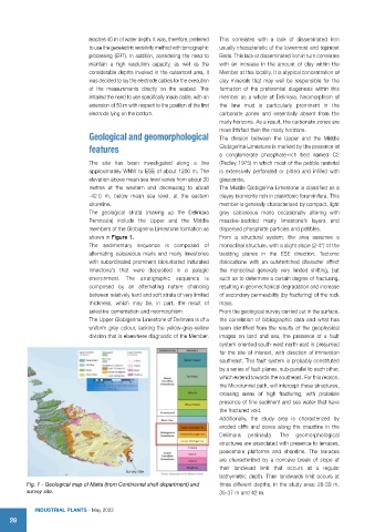
The site has been investigated along a line (Pedley 1975) in which most of the pebble material
approximately WNW to ESE of about 1200 m. The is extensively perforated or pitted and infilled with
elevation above mean sea level varies from about 30 glauconite.
metres at the western and decreasing to about The Middle Globigerina Limestone is classified as a
-42.0 m, below mean sea level, at the eastern clayey biomicrite rich in planktonic foraminifera. This
shoreline. member is generally characterised by compact, light
The geological strata (making up the Delimara grey calcareous marls occasionally altering with
Peninsula) include the Upper and the Middle massive-bedded marly limestone’s layers and
members of the Globigerina Limestone formation as dispersed phosphate particles and pebbles.
shown in Figure 1. From a structural system, the area assumes a
The sedimentary sequence is composed of monoclinal structure, with a slight slope (2-4°) of the
alternating calcareous marls and marly limestones bedding planes in the ESE direction. Tectonic
with subordinated prominent bioturbated indurated dislocations with an outstretched character affect
limestone’s that were deposited in a pelagic the monoclinal generally very limited shifting, but
environment. The stratigraphic sequence is such as to determine a certain degree of fracturing,
composed by an alternating nature chancing resulting in geomechanical degradation and increase
between relatively hard and soft strata of very limited of secondary permeability (by fracturing) of the rock
thickness, which may be, in part, the result of mass.
selective cementation and neomorphism. From the geological survey carried out in the surface,
The Upper Globigerina Limestone of Delimara is of a the correlation of bibliographic data and what has
uniform grey colour, lacking the yellow-grey-yellow been identified from the results of the geophysical
division that is elsewhere diagnostic of the Member. images on land and sea, the presence of a fault
system oriented south-west north-east is presumed
for the site of interest, with direction of immersion
southeast. This fault system is probably constituted
by a series of fault planes, sub-parallel to each other,
which extend towards the southeast. For this reason,
the Microtunnel path, will intercept these structures,
crossing areas of high fracturing, with probable
presence of fine sediment and sea water that have
the fractured void.
Additionally, the study area is characterized by
eroded cliffs and coves along the coastline in the
Delimara peninsula. The geomorphological
structures are associated with presence to terraces,
paleoshore platforms and shoreline. The terraces
are characterized by a concave break of slope at
their landward limit that occurs at a regular
bathymetric depth. Their landwards limit occurs at
Fig. 1 - Geological map of Malta (from Continental shelf department) and three different depths, in the study area: 28-30 m,
survey site. 35-37 m and 42 m.
IndustrIal Plants - May 2022
28