
Page 33 - Industrial Plants
P. 33
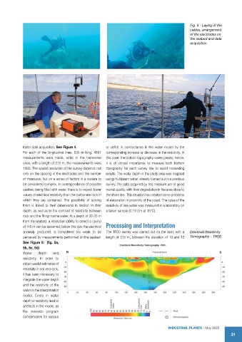
Fig. 5 - Laying of the
                                                                                               cables, arrangement
                                                                                               of the electrodes on
                                                                                               the seabed and data
                                                                                               acquisition


            faster data acquisition. See Figure 4.   or deficit in conductance in the water model by the
            For each of the longitu dinal lines, 635 m long, 4167   corresponding increase or decrease in the resistivity. In
            measurements were made, while in the transverse   this case, the bottom topography varies greatly; hence,
            ones, with a length of 315 m, the measurements were   it is of utmost importance to measure both bottom
            1565. The spatial resolution of the survey depends not   topography for each survey line to avoid misleading
            only on the spacing of the electrodes and the number   results. The water depth in the study area was mapped
            of measures, but on a series of factors in a system to   using multibeam sonar, already carried out in a previous
            be considered complex. In correspondence of possible   survey; the data acquired by this measure are of good
            cavities, being filled with water, there is to expect lower   overall quality, with their degradation in the area close to
            values of electrical resistivity than the carbonate rock in   the shore line. This situation has created some problems
            which they are contained. The possibility of solving   of elaboration in proximity of the coast. The value of the
            them is linked to their dimensions in relation to their   resistivity of sea water was measured in a laboratory on
            depth, as well as to the contrast of resistivity between   a taken sample (0.19 Ωm at 15°C).
            rock and the filling marine water. At a depth of 20-25 m
            from the seabed, a resolution (ability to detect a cavity)
            of 4-6 m can be assumed; below this size the electrical  Processing and Interpretation

            anomaly produced, is considered too weak to be   The TR00 survey was carried out on the land, with a   Electrical Resistivity
            perceived by measurements performed on the seabed.   length of 315 m, between the elevation of 10 and 13   Tomography – TR00.
            See Figure 5:  (fig. 5a,
            5b, 5c, 5d)
            Water   depth  and
            resistivity: In order to
            obtain useful estimates of
            resistivity in soil and rock,
            it has been necessary to
            integrate the water depth
            and the resistivity of the
            water in the interpretation
            model. Errors in water
            depth or resistivity lead to
            artefacts in the model, as
            the inversion program
            compensates for surplus

                                                                                    INDUSTRIAL PLANTS - May 2022
                                                                                                                   31